
|
|
Projects 2008
Improvements to the Letcombe Brook bank
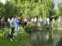
The improvements to the Letcombe Brook bank are completed. During September 2008, 120 Tonnes of soil was used to build up the bank between the Iron Footbridge and the first style, a distance of about 150m.
The soil has been seeded with a mixture of 80% grasses and 20% wild flowers as approved by the Environment Agency Conservation Officer.
45m of pre planted coir rolls were also laid in the stream bank edge to reduce erosion and provide a natural bank edge. The existing flagstones and some recovered from the stream have been relaid to be flush with the bank surface.
A big thanks to all who helped with this project.
Programme of selective weed clearance in Letcombe Brook between Lower Mill and Dandridges Mill
- Phase 1
Permission was obtained from the Environment Agency to carry out a programme of selective weed clearance in the brook between Lower Mill and Dandridges Mill.
A method statement/risk assessment was completed, plus a letter to land owners. [METHOD STATEMENT & RISK ASSESSMENT]
The work took place on 28th/29th June 2008 and by 5pm on Saturday, the level at the iron bridge had dropped 10.5 inches.
- Phase 2
Following the success of the big weeding event (Phase 1), more sessions were organised. Our aim was to remove the pinch points in the brook down stream of Lower Mill. The Environment Agency recognise that the weed clearing we have done has been very successful in dropping the water levels and allowing the natural flow of the stream to remove a lot of the silt and expose the natural gravel bed.
The environment Agency have committed to carry out regular maintenance in the future but the section down stream of Lower Mill needed attention before the winter.
We had five Saturday morning sessions from 9.00 am until noon on these days in 2008: 26th July, 9th August, 30th August, 13th September, 27th September.
Our aim was to remove all the pinch points as far as Venn Mill.
Letcombe Brook Water Height Measurements where, how and why
A Water level data logger has been set up upstream of Lower Mill, East Hanney (March 2008).
The water level data logger (Ref 1) consists of a pressure sensor and recording unit.
The senor is located in the water and this transmits the pressure to a recording unit.
The pressure is converted into water height by the recoding unit which takes into
account variation in temperature and atmospheric pressure. The logger is set up to
record every hour. The data is downloaded to a computer regularly.
By measuring the water level upstream of a weir then the volumetric flow rate can be
calculated (Ref 2). This information enables the flood group to calculate the actual
flow rate along the brook and so helps with our discussions with the Environment
Agency.
The data logger also shows the variation in water height over time and helps us
understand how quickly the brook water level responds to rainfall. It also shows some
unusual sudden changes which may be due to the operation of the Wantage Sewage
Treatment Works which has an outfall on the Letcombe Brook between East Hanney
and Grove.
The data logger was funded by East Hanney Parish Council and has been installed
with help from Robert Hodgson.
Water level graphs for each month since operation started on 9th March 2008 can be
downloaded from right hand side of this web page.
[Ref 1] WL16 (USB) 1-3ft range, manufactured by Global Water Inc.
(Ref 2) BS 3640-4E:1990 Measurement of liquid flow in open channels-Part 4E:
Rectangular broad-crested weirs
[DOWNLOAD VERSION]
Rainfall data private weather station at West Hendered
A graph showing rainfall recorded at a private weather station at West Hendered can be viewed. It is not strictly in the catchment but it is a good indication of what we experienced in 2007.

West Hendred May/Jun/Jul 2007 graph
|
|
|
|
